ESPOL Map
Company
ESPOLStack
Flex, ActionScript, PHPDate
Resources
A software for campus location and navigation using facial recognition
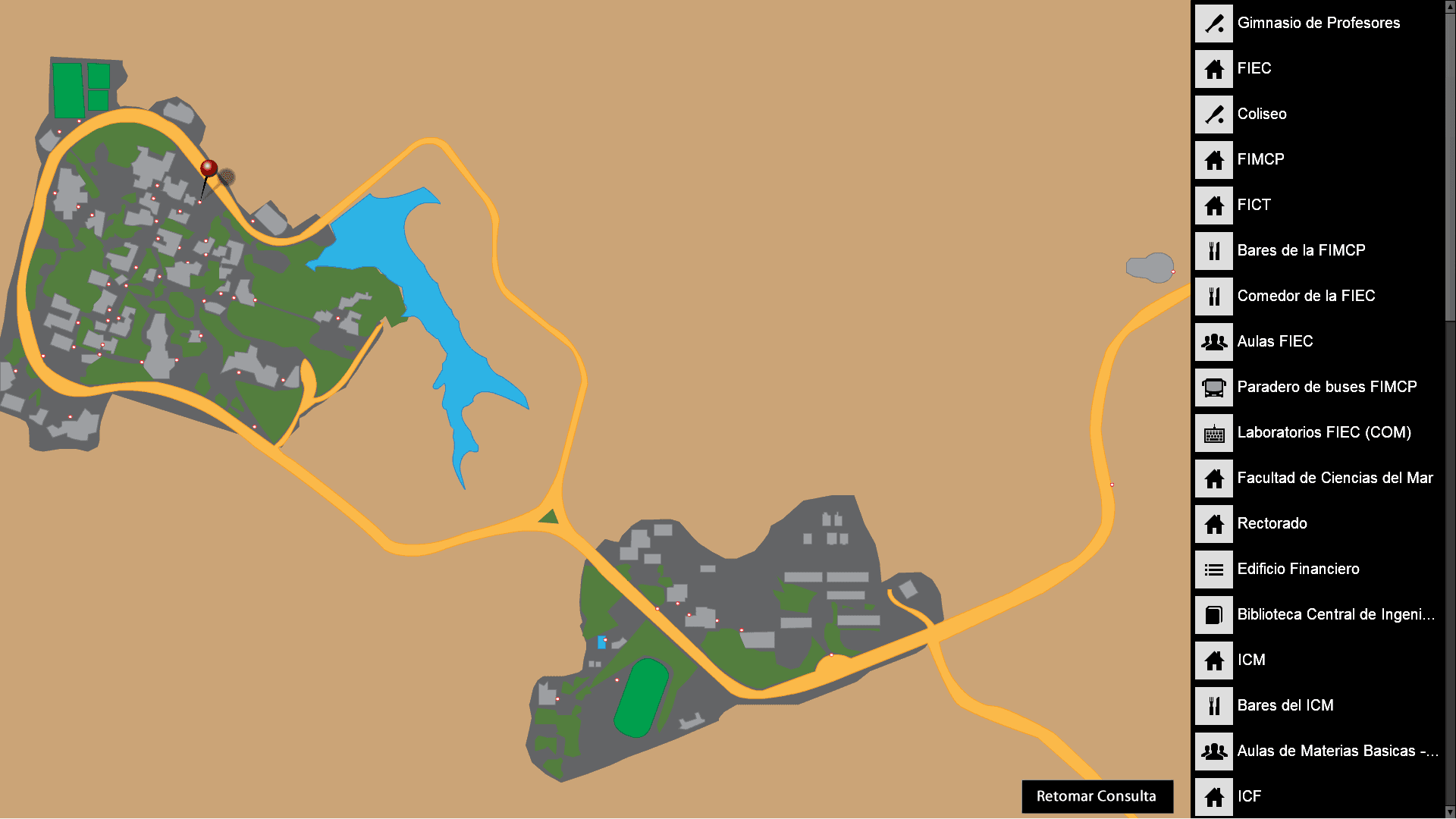
This work is a software system that allows users to locate different buildings and places on the campus of the Escuela Superior Politécnica del Litoral (ESPOL) in Ecuador. The system uses a virtual map, a touchscreen interface, and a facial recognition module to provide guidance and navigation to students and visitors.
The problem
The ESPOL campus is a large and complex area that contains various buildings and facilities for academic, administrative, and recreational purposes. The campus is constantly expanding and changing, making it difficult for students and visitors to navigate and find their destinations. Moreover, the campus does not have any effective signage or guidance system that can help users orient themselves and plan their routes. This caused frustration, confusion, and waste of time for users who are not familiar with the campus layout.
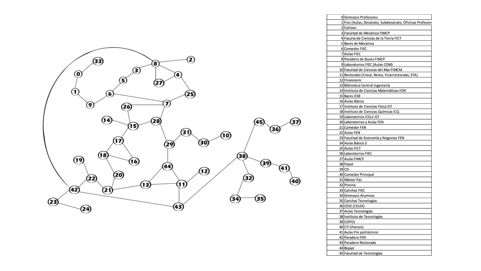
To solve this problem, I proposed to create a software system that can provide users with location and navigation services on the campus. The system would use a virtual map of the campus, a touchscreen interface, and a facial recognition module to interact with users and guide them to their desired places. The system would also store and recognize users’ faces linked to previous queries, allowing them to resume their searches from different locations. The system would be deployed on kiosks that would be installed at strategic points on the campus, such as entrances, exits, and main buildings.
Methodology
The project was developed using the following methods and tools:
- The software system was implemented using Flex Framework, a set of libraries for creating graphical user interfaces, and Action Script 3, a programming language that runs on Flash Player.
- The hardware system consisted of a touchscreen monitor, a CPU with a network card and a flash-compatible operating system, and a high-resolution camera. The hardware components were protected by a steel case and a plastic cover to prevent damage from weather and dust. The hardware would eventually be phased out for the use of personal mobile devices.
- Dijkstra’s algorithm is used to find the shortest route from the current location to the destination on the map. The algorithm uses a priority queue to store the nodes and their distances, and updates them as it explores the adjacent nodes.
- The facial recognition module used a library called FaceRecognitionLib.swc, which applies the Eigenface method to compare and identify faces from images. The images of the users were stored and processed on a remote server.
- The system was tested with various users and evaluated based on the accuracy, speed, and usability of the system.
The results
The project results showed that the system met the functional and non-functional requirements and achieved the objectives of the project. The system was able to:
- Provide a clear and precise response to the user’s query, showing the shortest route from the current location to the destination on the map.
- Take and store a photograph of the user’s face as the only identification data after each query.
- Recognize a user who had made a previous query and retrieve the information of the last query.
- Allow the user to resume a query from another location on the campus.